Home / Oahu Hiking Trails / Kaena Point Trail
Hiking the Kaena Point Trail - raw beauty trail


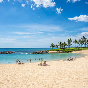
Travel to the end of the road on Oahu's West Side to the last white sand beach called Yokohama Bay, also known as Keawaula, and you’ll discover the trailhead to Kaena Point Trail. Dry, isolated, rugged coastline, and natural beauty are what you’ll find on this Oahu hiking trail. It’s a special one-of-kind beauty that you will not see anywhere else on the island.

Hike Details from Yokohama Bay
(West Side)
Elevation: 500 Feet
Length: Approx 2.5 Miles to the Point
Duration: 1-2 Hours
Terrain: Unpaved, Steep at times, Rocky
Difficulty: Moderate to Challenging
Hike Details from Mokuleia
(North Shore)
Elevation: 100 Feet
Length: Approx 2.5 Miles to the Point
Duration: 1-2 Hours
Terrain: Coastal, Dirt, Hot, Flat
Difficulty: Easy to Moderate
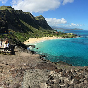
Not many visitors make it out to the northwesternmost tip of Oahu, simply because the roads do not connect and allow you to travel from the West Side to the North Shore.
Instead you find the road ending with a hiking trail at both ends. Hike out from either end and both will take you to Kaena Point State Park at the tip , a ruggedly beautiful remote park that is home to the Kaena Point Natural Area Reserve.
This reserve is a crucial habitat for a variety of native flora and fauna, including the Hawaiian monk seal and many seabirds like the Laysan albatross. This park offers a unique opportunity to experience Oahu's rugged coastline, far away from tourist-packed Waikiki!
Disclaimer – all Oahu hikes have different challenges and hazards that can be dangerous and may cause injury. Know your fitness and skill level before embarking on any hike. Stay on trails and obey posted signs. The information on this site is for your reading pleasure only. Hike at your own risk.
Hiking the Kaena Point Trail
As mentioned above, there are 2 separate entrances to the Kaena Point Trail. The first access point is located at the end of Yokahama Bay on the West Side. A second access point is at the end of the road along the Mokuleia coastline in the North Shore.

Both trails are about equal distance at approximately 2.5 miles from the start of the trailhead to the point, each offering unique scenic routes. The west side is full of switchback trails along the rugged coast.
You’ll get fantastic views of Yokohama Bay and of the west side of the island. Hike in from Mokuleia and you'll be rewarded with views of remote north shore coastline, and the stunning Waianae Mountain ridgeline ahead. It’s more of a direct route that sits a little further back from the coast, but it is elevated with great views.
Getting to Kaena Point Hike from the West Side

Drive on the Farrington Highway and pass through Waianae, Makaha, and other small towns, (which is a treat in itself), and allow extra time to enjoy Yokohama Bay (Keawaula Beach), one of the most beautiful beaches on the island.

The trail begins where the beach and paved road ends. Just past Yokohama Bay you’ll easily discover a dirt road walking trail. It’s wide enough to let 4x4 vehicles to pass through. In fact you’ll see a few abandoned cars along the way.
I particularly like this side of the Kaena Point Trail, as it winds through more switch backs and provides changing views of the Waianae Coast. During the winter time, you can see the migrating whales out in the ocean if you’re lucky!

And while it’s easy to climb down on the rocks to take a closer look at the coast and tide pools below, it can be dangerous with lots of hazards, like slippery and unstable rocks, and rough waves that smash against the rocky shoreline.
It’s remote out here with no lifeguards on duty to rescue anyone falling into the ocean or getting hurt. Be safe and stay on the trail while hiking!
As you wind through the turns, you’ll be rewarded with moon shaped coves, large tide pools, marine life and more!

There's a healthy amount of tide pools created as waves constantly pound the rocky shoreline and splashes water on top.
And while it’s not advisable to climb down onto the rocks, you’ll see an occasional local fisherman enjoying a day off, casting his pole into the deep blue sea.

On large surf days you might be treated to a couple of blow holes near the shore, spouting water high into the air. You know you’re close when you hear the blowholes breathing like a dragon! Pause for a moment and see water shoot into the air.
About midway along the trail there is a really cool rock formation with a huge puka (hole) in it, and a bridge platform on top. They call it the Kaena Point Arch, and it's a highlight for sure!
Getting to Kaena Point Trail from Mokuleia (North Shore)

Similar to the West Side, the Kaena Point Trail begins where the road ends in the North Shore. Take the Farrington Highway on the north shore to a parking lot at the end of the road.
 Hawaiian Monk Seal Beach along the Kaena Point Trail on the North Shore side.
The trail is a little more straightforward with sand dunes and endless North Shore coastline beauty to take in. This north side of the trail also features some isolated beaches along the way.

This Oahu hiking trail is easy to follow and it is well-maintained for the most part. Follow it two and half miles out to the point and you’ll reach the Kaena Point State Park which has a bird sanctuary that you can enter and explore. It is a bird lovers paradise!
If you're lucky you might also catch a good glimpse of a Hawaiian monk seal or two, sunning themselves on the warm sand. Remember to keep your distance and do not bother these or other sea animals...it's the law!
Ka’ena Point Natural Reserve
Once you reach what looks like a tall military-grade fence, you know you've reached a protected bird sanctuary. And while human visitors are allowed in, bird predators are kept out.
You will pass through a double gate and walk into a protected Hawaiian habitat with native plant species and seabirds like the indigenous Iwas and Boobies that nest in the area.

The trail is clearly marked with rope and signs. It goes without saying that you are required to remain on the trail to protect and not disturb the wildlife that make this area their home.
It tends to get a bit windy once you reach the point, but the trail opens up for exploring and the sandy area turns into a playground of discovery. Lots of sand dunes, tide pools and views to take in…!
Sign up for your own private tour (up to 6 people) that will pick you up and lead you to this Oahu hiking trail, along with discovering a few other secret spots on the West Side of the island. Discover here more...

There are information boards along the trails describing the significance of what you’re seeing. You’ll also come across the remains of an old military pillbox where it once stood along the shore. Enjoy the moment…you’ve earned it!
3 Similar Oahu Hiking Trails
Here are 3 additional Oahu Hiking Trails that are similar to hike, which you might want to consider climbing after this one...


Also consider exploring some other fun Oahu North Shore Hikes in the area from the Mokuleia side.
Kaena Point Trail Tips
- Start Early – it’s dry and tends to get hot on this side of the island, with no shade. Consider starting your hike earlier in the day.
- Parking – Do not tempt the thieves…lock up your car and do not leave anything for them to steal.
- Be Prepared – Bring plenty of water, hat, sunscreen, sunglasses, and a snack
- Be Safe – Hike with a partner, stay on the trail, and let someone else know where you’re going
- Facilities – Yokohama Bay has restrooms, outdoor showers, and a lifeguard on duty
- Food – there are no restaurants in the area. Your last chance to grab a bite or pick up some food is in the towns of Waianae or Haleiwa…depending on which side you’re traveling on.
Oahu Map
Getting There

The only way to get to Kaena Point is by car, which will take you over an hour. The Oahu bus turns around at Makaha, and you have another 15 minutes to travel by vehicle from there.
- From Waikiki, take the H-1 highway heading north
- Stay on H-1 until it ends and turns into the Farrington Hwy (Hwy 93)
- Follow the coast until the road ends at Keawa’ula Beach (Yokohama Bay)
In the Area
Yokahama Bay

You just might not make it out to Kaena Point once you see how beautiful Yokohama Bay is! And there’s a good chance you’ll have the beach to yourself, as it’s the most isolated beach on the island do to its location and effort to get there.
There is a life guard on duty, and make sure to check in with them as the waves here can be rough at times.
North Shore Attractions

If you are hiking from the Mokuleia side, you are surrounded by other north shore attractions that worth exploring after, including refueling from the popular shrimp trucks or cooling off with a shave ice in old town Haleiwa.
From popular big wave beaches to other popular hikes in the area, check out more in the North Shore.
Return to Best of Oahu Home Page
Aloha & Enjoy!
Subscribe to receive Best of Oahu updates on events, updates, and new articles. It's the closest way to paradise while you are away...
We will never sell or spam your information, and we'll respect your email privacy.


